22


R
D
BEE ME R AV
E
LILAC LN
RAINBOW ST
S DEER BLVD
SUNSET ST
WAY NE ST
Y
H
554TH AV E
7
LN
552N D A VE
E
AV
G
H
554TH AV E
ELKH ORN RIDG E
TO US HWY 81
8
AVE
26 – VISITORS GUIDE • YANKTON, SOUTH DAKOTA
RD
553RD
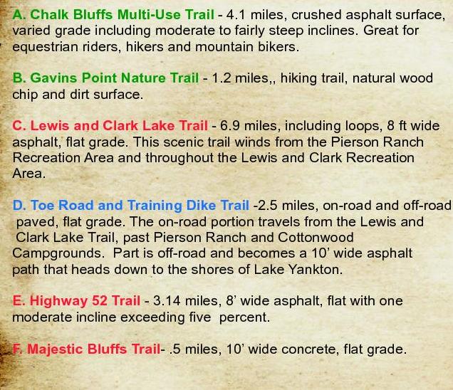
F. Majestic Bluffs Trail- .5 miles, 10’ wide concrete, flat grade.
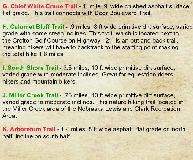
K. Arboretum Trail - 1.4 miles, 8 ft wide asphalt, flat grade on north
half, incline on south half.
6
r
GREENV IE W DR
897TH RD
AVE
E. Highway 52 Trail - 3.14 miles, 8’ wide asphalt, flat with one
moderate incline exceeding five percent.
ve
i Ri
so u r
T DR
BISO N TR
Mis
I
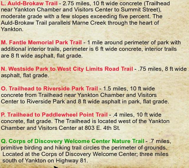
G. Chief White Crane Trail - 1 mile, 9’ wide crushed asphalt surface, L. Auld-Brokaw Trail - 2.75 miles, 10 ft wide concrete (Trailhead
flat grade. This trail connects with Deer Boulevard Trail.
near Yankton Chamber and Visitors Center to Summit Street),
moderate grade with a few slopes exceeding five percent. The
H. Calumet Bluff Trail - .9 miles, 8 ft wide primitive dirt surface, varied Auld-Brokaw Trail parallels Marne Creek through the heart of
grade with some steep inclines. This trail, which is located next to
Yankton.
the Crofton Golf Course on Highway 121, is an out and back trail,
meaning hikers will have to backtrack to the starting point making
M. Fantle Memorial Park Trail - 1 mile around perimeter of park with
the total hike 1.8 miles.
additional interior trails, perimeter is 6 ft wide concrete, interior trails
are 8 ft wide asphalt, flat grade.
I. South Shore Trail - 3.5 miles, 10 ft wide primitive dirt surface,
varied grade with moderate inclines. Great for equestrian riders,
N. Westside Park to West City Limits Road Trail - .75 miles, 8 ft wide
hikers and mountain bikers.
asphalt, flat grade.
J. Miller Creek Trail - .75 miles, 10 ft wide primitive dirt surface,
varied grade to moderate inclines. This nature hiking trail located in
the Miller Creek area of the Nebraska Lewis and Clark Recreation
Area.
KAR EN AVE
JAKE ST
Campground
552N D
D. Toe Road and Training Dike Trail -2.5 miles, on-road and off-road
paved, flat grade. The on-road portion travels from the Lewis and
Clark Lake Trail, past Pierson Ranch and Cottonwood
Campgrounds. Part is off-road and becomes a 10’ wide asphalt
path that heads down to the shores of Lake Yankton.
F
KAY ST
M OO N LI G H
S
RE
AC
C. Lewis and Clark Lake Trail - 6.9 miles, including loops, 8 ft wide
asphalt, flat grade. This scenic trail winds from the Pierson Ranch
Recreation Area and throughout the Lewis and Clark Recreation
Area.
OAK RIDGE RD
5
AY
B. Gavins Point Nature Trail - 1.2 miles,, hiking trail, natural wood
chip and dirt surface.
E
HORSESH OE
LOOP
Y
A
W
EA ES
ID CR
H
A
A. Chalk Bluffs Multi-Use Trail - 4.1 miles, crushed asphalt surface,
varied grade including moderate to fairly steep inclines. Great for
equestrian riders, hikers and mountain bikers.
D
HI
LL
S
AVE
C
AT
ER
550TH
B
W
T
ES
A
RD
CE
DA
R
CR
ELK
RIDG
E
DE
EP
GE
ID
KR
P
OA OO
L
LA KEVI
EW TE R
R
LL
HI
J
Burbach
8
ER
3
55
Area
Weigand Marina
RIV
DR
Lakeview
AW
DE
HI
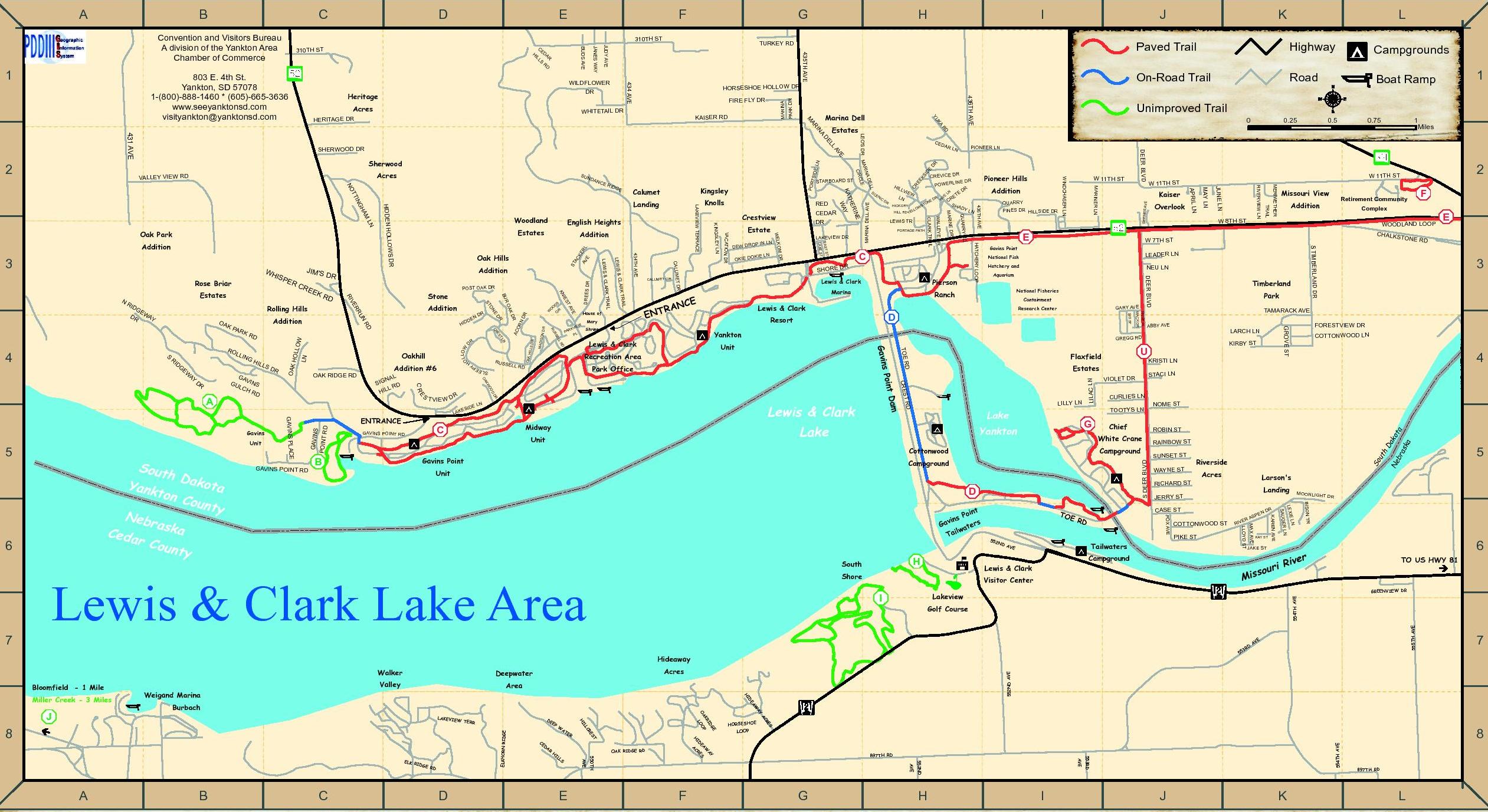
Miller Creek - 3 Miles
PIKE ST
EN
LN
LE XIE
LN
SAU GE R
Tailwaters
COTTONWOOD ST
P
AS
Golf Course
Acres
Deepwater
Landing
M AX AVE
LL O YD ST
FO X AV E
RD
Visitor Center
I
4
Larson's
JERRY ST
Hideaway
Valley
Acres
RICHARD ST
7
Walker
Riverside
CASE ST
Lewis & Clark
Shore
ROBIN ST
555TH AV E
EP
D
D A
VE
EAST ST: G3
NOME ST
So
ut
hD
ak
Ne
ot
br
a
ask
a
ID
KS
EE
W
YE
E LN
PO R
TSID
RL
KE
AV
E
DR E E S DR
ST
AC
R
DR
OR
ND
MAD IS
ON
AC
DR
OAK
HILL
S
D
LL OW
O
SL E
H OL L
OW
LN
E
Chief
Unit
H
STACI LN
Campground
552
N
COTTONWOOD LN
CURLIE S LN
Campground
TOE
FORESTVIEW DR
KRISTI LN
VIOLET DR
White Crane
Cottonwood
KIRBY ST
J
K
CALUMET CIR: F3
CALUMET DR: F3
CASE ST: J6
CEDAR HILLS RD: E1
CEDAR LN: H2
CHALKSTONE RD: K3, L3
CLARK TRAIL: H2, H3
COTTONWOOD LN: K4
COTTONWOOD ST: J6
CREEKSIDE DR: H2
CREST LN: D4
CREST RD: H3, H4, H5, H6
CRESTVIEW DR: D4, D5
CRETE DR: H2
CREVICE DR: H2
CURLIES LN: J4
DEER BLVD: J1, J2, J3, J4
DEW DROP IN LN: F3, G3
DREES DR: E3, E4
TAMARACK AVE
LARCH LN
U
TO OT YS LN
G
3
ASPEN CIR
GAVINS
P OIN T R
D
Park
GRO VE ST
Lake
E
S T IMBE RLAND DR
SID ST
LILLY LN
Yankton
South
WOODLAND LOOP
Timberland
ABBY AVE
Estates
nt
Poi
ins
s
Gav
te r
lwa
Ta i
TR AI L
GA RY AV E
Flaxfield
RD
Unit
M E RI W E T HE R
Containment
Research Center
Lake
RIV ERVI EW L N
National Fisheries
2
F
Complex
ABBY AVE: J4
ACORN DR: E4
APRIL LN: J2
BEEMER AVE: J2, J3
BISON TR: K5, K6
BUDS AVE: E1
BUR OAK DR: D3-4, E3-4
1
Miles
Retirement Community
Addition
NEU LN
T
CRES
Lewis & Clark
Missouri View
LE ADER LN
Aquarium
PAIGE PL
MAC K DR
Unit
Lewis & Clark Lake Area
Bloomfield - 1 Mile
MAY LN
Gavins Point
National Fish
D
Park Office
Midway
0.75
CHALKS
TONE R
D
Hatchery and
Ranch
Gavins Point
B
W 8T H ST
GR EG G R D
LN
I DE
0.5
W 7TH ST
Yankton
Recreation Area
JUNE LN
Marina
Lewis & Clark
Overlook
APRIL LN
Pierson
PINES DR HILLSIDE DR
DEER BLVD
Lewis & Clark
Resort
Lewis & Clark
?
0.25
1
Boat Ramp
W 11T H ST
W 11T H ST
Kaiser
E
HATCH ERY L O O P
C
QUARRY
43 6 TH AVE
DR
WA LL EY E D R
PORTAGE PATH
W 11TH ST
M ARI NE R LN
Addition
D
QU AR RY R
LEWIS TR
M A RI NE
OA K
Pioneer Hills
WIN D CH ASE R L N
DR
LVI
EW
LN
D
TO E R
S
0
PIONEER LN
LN
R
CR E V I CE D
L IN E D R
P O WE R
DR
E
ET
DR
CR
NE
TO
S HA
HICKORY
WS
DY
LO
LN
HILL RD YEL
HIL
t Dam
s Poin
Gavin
R
AR
DR
SHO RE
NC E
Shrine
D
SC
EN
IC
CL AR K TRA IL
RA
ENT
E
R IN
HE
KAT AY
W
ST
EAS T
LA KE S T
N
O M DR
N LN
KI E L
OK IE DO
WE L K
VAC ATI O N DR
TR AIL
Mary
OP I
DE W D R
LAKEVIEW DR
T DR
CL A R K
IL
W
VIE
RK
PA
PL
CA L U M E
&
LE WI S
43 4 TH AVE
AR K T R A
LE WI S & CL
D
LR
EL
SS
RU
EL L R
C
GAVINS POINT RD
VE
TA
GAVINS POINT RD
ENTRANCE
I ES
Sout
h Da
k ot a
Yank
ton C
ou n t
y
N ebr
aska
Ceda
r Co
u nt y
E
GAVINS PLAC
Unit
KN
T V IE W D
RU S S
House of
Estate
DR
DR
S
S
D
O
O
W CIR
CALUMET CIR
CEDAR
D
OO
KW
OA
L
NA
S IG
D
LR
HIL
E
LA K
Gavins
DR
Oakhill
Addition #6
OAK RIDGE RD
AK
SD
R
R
LN
GA
V IN
GU
S
LC
HR
D
T
ES
CR
IL L
DR
A
GH
C RE
DR
L IN
E
EW
AY
N
DR
ON
ST
RO
L
G
DE
HID
RD
RI
D
Addition
KR
D
Addition
N
RU
S
KP
AR
Stone
RO
RD
P O S T O A K DR
BU
EK
Addition
ER
OA
OW S D R
RE
Rolling Hills
Oak Hills
V
RI
DG
E
DR WAY
Addition
STARBOARD ST
RED
Crestview
KIN G SL EY L N
LN
Estates
RI
Knolls
English Heights
Estates
Kingsley
CE D
L
DE L
I NA
M AR
CL E
CIR
M
RC
Woodland
Calumet
LA KEVI EW TERR AC E
HA
PE
GE
Landing
L
HIDDE N HOL
G
TIN
Rose Briar
JIM'S
DR
R ID
Unimproved Trail
DEER BLVD
E
AV
T
NO
WH
IS
CE
Road
310TH ST: C1, E1, F1
431ST AVE: A1, A2, A3
434TH AVE: F1, F2, F3
435TH AVE: G1, G2, G3
436TH AVE: H1, H2, H3
Campgrounds
TIMBERLAND DR
LL
AN
Highway
RD
DE
ND
LE O' S D R
A
SU
KA
IN
Estates
YU
AR
M
431 AVE
Sherwood
Addition
6
Marina Dell
Street Index
L
On-Road Trail
SHERWOOD DR
3
5
FIRE FLY DR
KAISER RD
K
Paved Trail
HORSESHOE HOLLO W DR
WHITETAIL DR
Acres
J
436T H AVE
Acres
I
435T H AVE
DR
HERITAG E DR
Oak Park
4
434 AVE
WILDFLOWER
Heritage
H
TURKEY RD
JUD Y AVE
BUD S AVE
CE
HI D A
LL
R
S
RD
310T H S T
VA LLE Y VIEW RD
N
G
310TH ST
803 E. 4th St.
Yankton, SD 57078
1-(800)-888-1460 * (605)-665-3636
www.seeyanktonsd.com
visityankton@yanktonsd.com
2
F
JAN ES WAY
1
E
CR
Convention and Visitors Bureau
A division of the Yankton Area
Chamber of Commerce
D
M ARI NA DE LL AVE
C
PAR K DR
B
M A RI NA
A
897TH RD
L
R. James River Trail – 4.3 miles, 5 ft wide, paved only one mile
and flat from Rotary Park along East 7th Street, Highway 50, Ferdig
Avenue and East 8th Street. The primitive and scenic trail
continues from East 8th Street out to the James River and has
various grades, including moderate to fairly steep inclines.
S. Marne Creek West Trail - .75 miles, it is a 10’ wide soft-surface
trail that connects 23rd street to the Marne Creek West Greenway
which is home to the community garden and the City’s dog park.
The trail does have a moderately steep elevation change.
FIRE FLY DR: G1
FORESTVIEW DR: K4
FOX AVE: J6
GARY AVE: J3
GAVINS GULCH RD: B4
GAVINS PL: C5
GAVINS POINT RD: C5, D5
GREGG RD: J3, J4
GROVE ST: K4
HATCHERY LOOP: H3
HERITAGE DR: C1
HICKORY HILL RD: H2
HIDDEN DR: D3, D4
HIDDEN HOLLOWS DR: C2, D3
HILLSIDE DR: I2, I3
HILLVIEW LN: H2
HORSESHOE HOLLOW DR: G1
JAKE ST: K6
JANES WAY: E1
JERRY ST: J5
JIM'S DR: C3
JUDY AVE: E1
JUNE LN: J2
RAINBOW ST: J5
RED CEDAR DR: G2, G3
RICHARD ST: J5
RIVER ASPEN RD: J6, K5-6
RIVERRUN RD: C3, C4
RIVERVIEW LN: K2
ROBIN ST: J5
ROLLING HILLS DR: B4, C4, C5
RUSSELL RD: D4, E4
S DEER BLVD: J4, J5, J6
S RIDGEWAY DR: B4
S TIMBERLAND DR: K3, K4
SAUGER LN: K6
SCENIC DR: H2
SD HWY 314: J1, K1, K2, L2
SD HW 52: C1-4, D4-5, E4, F3-4, G3, H3
I3, J3, K2-3, L2-3
SHADY LN: H2
SHERWOOD DR: C2
SHORE DR: G3, H3
SID ST: J3, J4
SIGNAL HILL RD: D4
SLEEPY HOLLOW DR: D4, E4
STACI LN: J4
STACKERL AVE: E3
STARBOARD ST: G2
STONE DR: D3, D4
SUNDANCE RIDGE: D1, E1, E2, F2
SUNSET ST: J5
TAMARACK AVE: K4
TIMBERLAND DR: K1
TOE RD: H3, H4, H5, H6, I5, I6, J6
TOOTYS LN: J5
TURKEY RD: G1
VACATION DR: F3
VALLEY VIEW RD: A2, B2, B3
VIOLET DR: I4, J4
W 11TH ST: I2, J2, K2, L2
W 7TH ST: J3
W 8TH ST: H3, I3, J3, K3, L2, L3
WALLEYE DR: H2, H3
WAYNE ST: J5
WELKOM DR: G3
WHISPER CREEK RD: C3
WHITETAIL DR: E1, F1
WILDFLOWER DR: E1, E2
WINDCHASER LN: I2, I3
WOODLAND LOOP: L2
WOODS CIR: E3
WYE LN: H2
YELLOWSTONE DR: H2
YUKA RD: H1, H2
Roads Not Labeled in Yankton:
KAISER RD: F1, G1
KAREN AVE: K6
KATHERINE WAY: G2, G3
KAY ST: K6
KINGSLEY LANE: F3
KIRBY ST: K4
KNIEST AVE: E3, E4
KRISTI LN: J4
LAKE ST: G3
LAKESIDE LN: D4, D5
LAKEVIEW DR: G3
LAKEVIEW TERRACE: F2, F3
LARCH LN: K4
LEADER LN: J3
LEO'S DR: G2
LEWIS & CLARK TRL: E3-4, F3-4
LEWIS TR: H2, H3
LEXIE LN: K6
LILAC LN: I4
LILLY LN: I4
LLOYD ST: K6
MACK DR: J3, J4
MADISON DR: E4
MARINA DELL AVE: G1-G3, H2
MARINA DELL CIRCLE: G2, H2
MARINA PARK DR: G1
MARINE DR: H3
MARINER LN: I2, I3
MAX AVE: K6
MAY LN: J2
MERIWEATHER TRAIL: K2
MOONLIGHT DR: K5
N RIDGEWAY DR: A3, A4, B4
NEU LN: J3
NOME ST: J4
NOTTINGHAM LN: C2, C3
O. Trailhead to Riverside Park Trail - 1.5 miles, 10 ft wide
concrete from Trailhead near Yankton Chamber and Visitors
Center to Riverside Park and 8 ft wide asphalt in park, flat grade.
T. Meridian Bridge Trail- .5 miles each level, 12’ concrete, no slope
on lower level, steep slope on upper level entry ramps. This trail is
the historic double-deck Meridian Bridge, which had its dedication
ceremony on October 11, 1924. The bridge spans the Missouri
National Recreational River, which is a National Park.
OAK HILLS DR: E4
OAK HOLLOW LN: C4
OAK PARK RD: B4
OAK RIDGE RD: C4
OAKWOOD DR: D4
OKIE DOKIE LN: F3, G3
P. Trailhead to Paddlewheel Point Trail - .4 miles, 10 ft wide
concrete, flat grade. The Trailhead is located west of the Yankton
Chamber and Visitors Center at 803 E. 4th St.
U. Deer Boulevard Trail - .4 miles, 10 ft wide, crushed asphalt surface,
flat grade. This trail connects with Chief White Crane and
Lewis and Clark Lake Trail.
PAIGE PL: J3, J4
PARKVIEW PL: E4
PIKE ST: J6
PIONEER LN: H2, I2
PORTAGE PATH: H3
PORTSIDE LN: G2
POST OAK DR: D3
POWERLINE DR: H2
Q. Corps of Discovery Welcome Center Nature Trail - .7 miles,
primitive birding and hiking trail circles the perimeter of grounds.
Located at the Corps of Discovery Welcome Center; three miles
south of Yankton on Highway 81.
QUARRY PINES DR: H2, I2-3
QUARRY RD: H2, H3
BALD EAGLE DR: E4
BAYCLIFFE DR: F2, F3
BENEDICTINE LN: L2
DEBRA BLVD: J3, K3
DEER CROSSING : B4
FRONTAGE RD: I3
HYLINE LOOP: H2
KALEA ST: K3
MARINA BLUFFS CRT: G3
MARINA BLUFFS RD: G3
MIDWAY GULCH RD: E4
N KATHERINE WAY: G2
N TIMBERLAND DR: K3, K4
PREMIER CIR: J3, K3
SISTER GROVE RD: L3
SOUTH VIEW RD: J2
Nebraska Roads:
552ND AVE: H6, H8, I6, I7, I8
553RD AVE: I8, J7, J8, K7
554TH AVE: K6, K7, K8
555TH AVE: L6, L7, L8
897TH RD: D8, E8, F8, G8, H8, I8, J8, K8, L8
CEDAR HILLS: E8
DEEP WATER: E8
ELK RIDGE RD: D8
ELKHORN RIDGE: D8
GREENVIEW DR: L6
HIDEAWAY ACRES: F7, F8, G8
HILLCREST: E8
HORSESHOE LOOP: F8, G8
LAKEVIEW TERR: D8
NE HWY 121: G7, G8, H6-7, I6-7
J6, K7, L6
OAK RIDGE RD: E8, F8
OAKRIDGE LOOP: F8
Roads Not Labeled in Nebraska:
550TH AVE: E8
BEACH RD: D8
CROOKED OAKS: F8
EASTSIDE DR: D8
ESTHER ST: D8
FOX BURR: F8
LEWIS & CLARK DR: D8
LOIS ST: C8
MAIN ST: D8
MARK ST: C8, D8
MARY ST: C8, D8
OAK DR: D8
RIDGE RD: C8, D8
RUTH ST: C8, D8
SHADY LAND DR: D8
SHADY LANE RD: C8, D8
TIMBERLINE TR: F8
WILDERWOOD WAY: E8, F8
VISITORS GUIDE • YANKTON, SOUTH DAKOTA – 23


































 Previous Page

