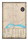
K. Arboretum Trail
1.4 miles, 8’ wide asphalt, flat grade on north half,
incline on south half. The Arboretum Trail follows
the perimeter of the Yankton High School and
Summit Activities Center located at 1801 Summit
St.
L. Auld-Brokaw Trail
2.75 miles, 10’ wide concrete (Trailhead near
Yankton Chamber & Visitors Center to Summit
Street), moderate grade with a few slopes
exceeding five percent. The Auld-Brokaw Trail
parallels Marne Creek through the heart of
Yankton.
M. Fantle Memorial Park Trail
1 mile around perimeter of park with additional
interior trails, perimeter is 6’ wide concrete,
interior trails are 8’ wide asphalt, flat grade.
Memorial Park is located along Douglas Avenue
and Mulberry Street between 19th Street and 21st
Street
N. Westside Park to
West City Limits Road Trail
.75 miles, 8’ wide concrete, flat grade. This section
of the trail stretches from Westside Park, located at
West 5th Street and Summit Street, to the western
edge of Yankton.
O. Trailhead to Riverside Park Trail
1.5 miles, 10’ wide concrete from Trailhead near
Yankton Chamber & Visitors Center to Riverside
Park and 8’ wide asphalt in park, flat grade. This
section of the trail follows Marne Creek to the
Missouri River and then meanders along the
Missouri River through Riverside Park.
P. Trailhead to Paddlewheel Point Trail
.4 miles, 10’ wide concrete, flat grade. The
Trailhead is located west of the Yankton
Chamber & Visitors Center at 803 E. 4th St.
Q. Corps of Discovery Welcome Center
Nature Trail
.7 miles, primitive birding and hiking trail. At the
Corps of Discovery Welcome Center, located three
miles south of Yankton on Highway 81, you will
find a birding and hiking trail that circles the
perimeter of the grounds.
R. James River Trail
.3 miles, 5’ wide, paved only one mile and flat
from Rotary Park along East 7th Street, Highway
50, Ferdig Avenue and East 8th Street. The
primitive and scenic trail continues from East 8th
Street out to the James River and has various
grades, including moderate to fairly steep inclines.
S. Marne Creek West Greenway Trail
.25 miles, 8’ wide crushed concrete, slight slope.
This trail leads from the Marne Creek West
Greenway, home to the community gardens and
dog park and located along West City Limits Road,
to the on-street trail of 23rd Street.
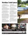
T. Meridian Bridge Trail
.5 miles each level, 12’ concrete, no slope on lower
level, steep slope on upper level entry ramps. This
trail is the historic double-deck Meridian Bridge,
which had its dedication ceremony on October 11,
1924. The bridge spans the Missouri National
Recreational River, which is a National Park.
U. Deer Boulevard Trail
1.875 miles, 10’ wide, crushed asphalt surface, flat
grade. This trail connects with Chief White Crane
Trail and Lewis and Clark Lake Trail.
V. Nebraska Primitive Trail
1 mile, 8’ wide primitive dirt surface, mostly flat
grade with a few steep inclines. This nature
hiking/biking trail is located on the south side of
the Meridian Bridge in the property to the west of
the old Highway 81 roadway. Signage will guide
you to the trail access points. Parking is available
on the south side of the Meridian Bridge. The trail
forms a figure eight amongst the trees. The north
loop provides access to the Missouri River and its
sandy shoreline.
W. Nebraska Meridian Trail
1.2 miles, 10’ wide asphalt, flat to moderate
grades. This begins east of Gavins Point Dam and
runs along the Missouri River and Highway 121 to
Murdo’s Restaurant in Aten. This is the first phase
of the Nebraska Meridian Trail system. Upon
completion the trail is planned to connect Gavins
Point Dam and the Meridian Bridge providing a
trail system linking Nebraska and South Dakota.
VISITORS GUIDE • YANKTON, SOUTH DAKOTA – 43


 Previous Page